
Introduction
Understanding the variability of rainfall patterns and their implications on crop production has been the subject of important discussion and significant research on climate change. Establishing the relationship between the rainfall patterns, trends, and intensity with crop production provides insights into how fluctuations in seasonal rainfall impact agricultural yield. Rainfall variability tends to be more pronounced in minor seasons, which correlates with a deficit in crop production.1
Rainfall variability and trends play a pivotal role in determining water availability for agriculture. Seasonal water shortages contribute to variations in crop production.2,3 In the Thamirabharani River Basin, researchers examined rainfall variability using statistical methods such as the Coefficient of Variation (CV), PCI, Mann-Kendall test, Sen’s slope test, and ITA. The analysis highlighted an increasing trend in annual rainfall, particularly in plains and coastal regions.4 The Upper Zambezi River Basin study analyzed rainfall characteristics and their correlation with maize production using the SVAT model and bias-corrected TRMM-B42 V6 rainfall estimates. The study found that longer rainy seasons positively impact maize yields, while short rainfall periods with frequent dry spells hinder agricultural success.5
Several models have been utilized to assess the effects of climate change on crop phenology and yield. STICS and APSIM models were employed to evaluate the impact of climate change on winter wheat in rainfed and irrigated areas of Pakistan under RCP 4.5 and RCP 8.5 scenarios. Results from these models showed that climate change significantly affects crop yield, with the STICS model indicating better outcomes when sowing and irrigation practices are optimized under the RCP 4.5 scenario.6 In the Columbia River Basin, the Variable Infiltration Capacity (VIC) hydrological model was used to assess the impacts of 21st-century climate change on irrigation demand. The study found short-term positive impacts on water availability for irrigation, but long-term projections indicated negative consequences.7 Similarly, the impact of climate change on the Kabul River Basin has been assessed using MODIS satellite data to study snow cover and river flow variability. It was observed that rising temperatures result in reduced snow cover during summer months, with maximum snow cover recorded in February due to lower temperatures and increased winter rainfall.8
The effects of climate change on crop productivity have been widely studied. In the Heihe River Basin, researchers evaluated 31 climate models to simulate future rainfall and temperature changes, projecting negative impacts on wheat, barley, and canola yields while predicting positive effects on maize production.9 Similarly, in Africa, the impact of climate change on small river basins was examined using two general circulation models (GCMs) under different greenhouse gas scenarios. The findings revealed decreased rainfall in northern and southern Africa, affecting land use and crop productivity.10 The Mekong River Basin study focused on rice production and water productivity, concluding that current productivity levels are sufficient to meet population demands until 2050. The study emphasized the potential to further improve productivity to maintain the basin’s carrying capacity.11
In India, the Sabarmati River Basin study utilized a multi-model ensemble approach under RCP scenarios to analyze aridity and spatio-temporal changes. The study found a positive correlation between increased rainfall and crop production, while temperature increases led to anthesis heat stress (AHS) affecting Kharif and Rabi crops.12 In the Baghmati River Basin, a spatio-temporal study used hydrological and GIS datasets, along with the Statistical Downscaling Model (SDSM) and CROPWAT 8.0, to forecast temperature, rainfall, and irrigation water requirements for rice and wheat. The findings suggested that small, farmer-managed irrigation schemes could sufficiently meet water demands despite declining irrigation water trends in mid-hill and high-hill regions.13 Rainfall variability significantly impacts cereal crop productivity, particularly in regions dependent on monsoonal rains for agricultural activities. The Baghmati-Kosi Doab, located in the eastern part of Nepal, is a crucial agricultural region where farmers rely heavily on rainfall to cultivate staple cereal crops such as rice, wheat, and maize. Over the past two decades (2002-2023), the region has experienced notable changes in rainfall patterns, influencing crop yields and posing challenges to food security.
The Kosi River Basin in Nepal has been extensively studied for its climate and crop production trends, and it revealed that increasing temperatures during the growing season negatively impacted rice, wheat, and maize yields, except in high-altitude areas where temperature increases benefited crop production.14 Changes in cultivable land in the Koshi River Basin were also investigated using GIS tools and a binary logistic regression model. The study found a rapid increase in agricultural land post-1978, followed by a slight decline in 2010. Topography, socio-economic factors, climate, and proximity to roads, rivers, and settlements were identified as key drivers of agricultural land changes.15
Several studies undertaken in India have investigated the effects of climate variability on agriculture and water resources. Another study analyzed temperature and rainfall impacts on crop production in Kullu district, Himachal Pradesh (1971–2016), using the Mann-Kendall test and regression methods.16 They found an increase of 0.02°C in the average minimum temperature during the Rabi and Kharif seasons, while daily temperature decreased by 0.02°C in the Kharif season, affecting crop productivity. A multivariate analysis of rainfall and temperature trends on maize and wheat in Himachal Pradesh, reported positive trends in both variables17. High Kharif season temperatures negatively impacted maize but benefitted wheat during the Rabi season, with rainfall positively influencing both crops.17 Similarly, in Punjab, rising temperatures were found to reduce productivity in major crops.18 A study on the Krishna River Basin using the SWAT model observed increased rainfall and surface runoff, particularly during October and November.19 Examination of century-long rainfall trends in nine river basins, found an increasing trend in most of the basins, with the Indus basin showing the highest increase. In contrast, rainfall remained stable in the Ganga, Sabarmati, Brahmani, and Subarnarekha basins.20 All these studies underline the significant impact of climate variability on agriculture and water resources in India.
The present study statistically analyzes rainfall trends and their impact on cereal crop productivity in the Baghmati-Kosi Doab in North Bihar. By employing robust statistical techniques, including the Modified Mann-Kendall trend test, Sen’s slope estimator, and rainfall concentration index (PCI), the study investigates temporal changes in rainfall patterns and their correlations with crop production data. The findings will enhance understanding of how rainfall variability affects agricultural productivity and will inform the development of climate-resilient farming practices in the region. Additionally, this research will provide insights into the effectiveness of current water management practices and the need for adaptive measures to mitigate the adverse effects of climate change on cereal crop yields.
Objectives of the study
To assess the rainfall pattern in Baghmati-Kosi Doab.
To determine the correlation and analysis between rainfall patterns and crop productivity in the study area.
Research Questions
What are the trends and seasonal variations in rainfall in the Baghmati-Kosi Doab region over recent decades?
What is the relationship between annual rainfall variability and the productivity of major crops in the region?
Materials and Methods
Study Area
The Baghmati-Kosi Doab (BKD) is a fertile region located in the Mithila Plain (Zone-I) of North Bihar. The Baghmati River geographically bounds it to the west, the Kosi River to the east, and Nepal to the north, forming a natural boundary. The area spans latitudes 25°32′14″N to 26°53′14″N and longitudes 85°15′27″E to 86°48′25″E. The BKD region encompasses parts of nine districts in North Bihar, including significant portions of Sitamarhi, Madhubani, and Darbhanga, along with about 10% of Sheohar, Muzaffarpur, Samastipur, Khagaria, Saharsa, and Supaul districts. Situated at the foothills of the Shivalik range, this region is a dynamic floodplain shaped by Himalayan rivers such as the Baghmati, Adhwara, Kamla, and Kosi, which deposit new alluvial soil annually, making the land highly fertile for agriculture.
The area experiences a subtropical monsoon climate (Cwa) with an annual rainfall of approximately 1,200 mm. Major crops include rice, wheat, maize, green gram, and mustard, primarily dependent on monsoon rains. However, the unpredictability of the monsoon and the lack of an efficient irrigation system have led to an increased reliance on groundwater. The region’s average evapotranspiration rate is 110.79 mm/day, while its average potential evapotranspiration is 529.87 mm/day.
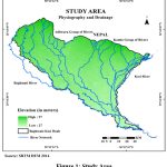 |
Figure 1: Study Area |
The study area’s total population is 29,853,835, with an average population density of 1,392 people per square kilometer and a literacy rate of 57.23%. Despite its agricultural potential, farmers face significant challenges such as droughts, floods, erratic rainfall, rising temperatures, and other climate change-induced issues. These factors not only threaten livelihoods but also impose economic hardships. To address these challenges, farmers need to adopt climate-resilient agricultural practices to mitigate the impacts of climate change and ensure sustainable farming in the region.
Data Sources and Methods
This research study used secondary data for data collection. High-resolution satellite imagery, specifically SRTM DEM 2014, is obtained from the United States Geological Survey (USGS) to analyze the region’s topography. District-wise rainfall data for the Baghmati-Kosi Doab region, spanning the period from 1993 to 2022, is collected from the India Meteorological Department (IMD). Additionally, agricultural productivity data for major crops, including rice, wheat, and maize, is sourced from government reports of the Economic Survey of Bihar, covering the years 2000 to 2022. The hydrological analysis focuses on SRTM DEM data to study the drainage patterns and physiographic features of the region. Seasonal and annual values of evapotranspiration (ET) and potential evapotranspiration (PET) are calculated to assess water demand. Rainfall trends and variability are analyzed using statistical methods such as the Modified Mann-Kendall (MMK) Test and Sen’s Slope estimator. Meanwhile, crop productivity data is analyzed to identify trends and assess the impact of climatic variables on agricultural yields.
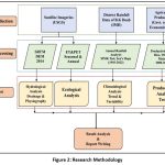 |
Figure 2: Research Methodology |
Results
Rainfall Trends and Variability in the Baghmati-Kosi Doab
The Baghmati-Kosi Doab region has experienced significant variability in annual rainfall patterns from 1993 to 2022. The analysis of annual rainfall data for this period indicates a decreasing trend in rainfall over the years. The Sen’s slope estimator, a non-parametric method for determining the magnitude of a trend, shows a negative slope, suggesting a gradual decline in rainfall amounts over time. The test Z-Score of -1.28 indicated a non-significant decreasing trend. The Sen’s Slope value of -8.86mm/year indicated decreased rainfall annually.
The trendline plotted over the annual rainfall bars highlights this downward trend ( Figure 3).
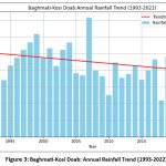 |
Figure 3: Baghmati-Kosi Doab: Annual Rainfall Trend (1993-2022)Click here to view Figure |
During the study period, rainfall exhibited fluctuations, with peak rainfall recorded in the early 2000s and a noticeable decline in recent years. The variability in rainfall patterns may be attributed to several factors, including climate change, shifts in monsoonal activity, and anthropogenic influences. The declining trend is concerning, as it impacts water availability for agriculture, a primary livelihood source in the region. Reduced rainfall can lead to water stress, affecting crop yields and agricultural productivity. Understanding these rainfall trends is essential for developing effective water management and climate adaptation strategies to mitigate the impacts of changing precipitation patterns.
Analysis of evapotranspiration and potential evapotranspiration in Baghmati-Kosi Doab
The Baghmati-Kosi Doab region’s annual actual evapotranspiration (ET) and potential evapotranspiration (PET) from 2002 to 2023 highlight the region’s water balance and the atmospheric demand for moisture. The data, derived from Terra MODIS MOD16A2GF, shows variations in both ET and PET over the years ( Figure 4).
Potential evapotranspiration (PET) represents the atmospheric demand for moisture if sufficient water is available, while actual evapotranspiration (ET) reflects the actual water loss from the surface due to evapotranspiration processes. The observed PET values range between 2,300 mm to 2,700 mm per year, indicating high atmospheric demand for moisture in the region. On the other hand, actual ET values show significant fluctuations, ranging from 400 mm to 700 mm annually, which suggests that water availability is a limiting factor for evapotranspiration.
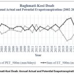 |
Figure 4: Baghmati-Kosi Doab: Annual Actual and Potential Evapotranspiration (1993-2022)Click here to view Figure |
The analysis indicates that PET remained relatively stable over the years, whereas ET showed more variability, especially during the later years of the study period. The declining trend in ET observed after 2020 might be attributed to reduced water availability, possibly linked to the decreasing rainfall trend in the region.
Comparative analysis of annual rainfall and ET & PET in Baghmati-Kosi Doab
The Baghmati-Kosi Doab region has shown significant changes in annual rainfall, actual evapotranspiration (ET), and potential evapotranspiration (PET) over the past three decades, which have critical implications for its agrarian economy. The analysis of rainfall data from 1993 to 2022 reveals a declining trend, as indicated by Sen’s slope estimator (-8.86mm/year). This reduction in rainfall directly impacts water availability for agriculture, the primary livelihood in the region. Fluctuations in monsoonal activity, climate change, and human-induced changes are potential drivers of this variability. Peak rainfall was recorded in the early 2000s, but recent years have seen a notable decline, raising concerns about water scarcity for crop production.
The evapotranspiration analysis from 2002 to 2023 further highlights the region’s water balance challenges. PET values range between 2,300 mm to 2,700 mm annually, reflecting a consistently high atmospheric demand for moisture. However, actual ET fluctuated significantly, ranging from 400 mm to 700 mm, indicating that water availability often limits evapotranspiration processes. While PET remained relatively stable over the years, ET showed increasing variability, especially after 2020, coinciding with reduced rainfall.
The declining rainfall and fluctuating ET pose serious challenges for the region’s agrarian economy. Reduced rainfall increases the risk of water stress, directly impacting crop yields and agricultural productivity. High PET values further indicate that the atmospheric demand for moisture exceeds available water resources, making irrigation management critical. The observed trends call for adaptive strategies, such as efficient water use, improved irrigation practices, and climate-resilient crops.
Comparative analysis of crop productivity and annual rainfall in Baghmati-Kosi Doab
Figure 5 depicts the average productivity of cereals (rice, wheat, and maize) in the Baghmati-Kosi Doab region from 2000 to 2022. It shows that maize consistently had the highest productivity, followed by wheat and rice. While maize productivity experienced a steady increase, especially from 2015 onwards, rice and wheat showed only marginal improvements over the study period.
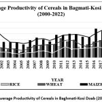 |
Figure 5: Average Productivity of Cereals in Baghmati-Kosi Doab (2000-2022)Click here to view Table |
Relating this to the rainfall data, the declining trend in annual rainfall appears to have impacted agricultural productivity differently for each crop. Maize, which shows the most significant productivity increase, might be more resilient to reduced rainfall or has benefited from improved agricultural practices, such as the use of drought-tolerant varieties or better irrigation systems. Wheat productivity showed moderate improvement, suggesting some sensitivity to declining rainfall but possibly offset by adaptation measures. In contrast, rice productivity remained relatively stagnant, reflecting its dependence on consistent and adequate water supply, as rice is a water-intensive crop.
The decline in rainfall is likely to lead to water stress in the region (-8.86mm/year). This is particularly significant in a region where agriculture is rainfall-dependent. The impact of fluctuating rainfall patterns, especially in critical monsoon periods, might explain variations in crop productivity, with wetter years potentially boosting yields.
These findings underscore the necessity for adaptive strategies, such as promoting water-efficient crop varieties, improving irrigation infrastructure, and adopting sustainable agricultural practices. Addressing water availability challenges due to reduced rainfall is critical to sustaining and improving agricultural productivity in the Baghmati-Kosi Doab region amidst ongoing climate change impacts.
Discussion
The findings of this study highlight the critical relationship between rainfall variability, evapotranspiration, and cereal crop productivity in the Baghmati-Kosi Doab region of North Bihar. The study provides a nuanced understanding of how declining rainfall and fluctuating water availability influence agricultural productivity, a primary livelihood in this region.
The analysis reveals a notable decline in annual rainfall over the past three decades, with Sen’s slope estimator indicating a statistically significant negative trend (-8.86mm/year) This reduction in rainfall, coupled with the consistently high atmospheric demand for moisture as indicated by stable PET values, has created a challenging environment for agriculture. Actual evapotranspiration (ET) fluctuated widely, reflecting water availability constraints, particularly after 2020, when ET values showed a further decline. These findings underscore the increasing vulnerability of the region’s water resources to climate-induced variability.
The comparative analysis of rainfall trends and crop productivity shows differential impacts across cereal crops. Maize productivity demonstrated a steady rise, likely due to its relative resilience to water scarcity or the adoption of improved agricultural practices, including drought-tolerant crop varieties. Wheat productivity showed modest improvements, while rice, the most water-dependent crop, exhibited stagnant growth, indicating a greater susceptibility to declining rainfall and water stress.
Studies from other regions validate these findings, emphasizing the critical role of adaptive measures in mitigating the impacts of climate change on agriculture. The reliance on groundwater for irrigation in the Baghmati-Kosi Doab region, as highlighted in the study, reflects an adaptive response to monsoonal unpredictability. However, over-extraction of groundwater poses long-term sustainability risks. The need for integrated water management strategies that balance surface and groundwater use is critical to sustaining agricultural productivity.
Conclusion and Recommmendations
This study highlights the significant decline in annual rainfall in the Baghmati-Kosi Doab region over the past three decades, with Sen’s slope indicating a negative trend of -8.86mm/year. The high variability in evapotranspiration levels, coupled with consistently high potential evapotranspiration (PET), suggests increasing water stress in the region. These changes have had a direct impact on agricultural productivity, particularly for water-intensive crops like rice and wheat. In contrast, maize has shown relative persistence, possibly due to improved farming practices and drought-resistant varieties. The findings demand an urgent need for effective water management and climate adaptation strategies to mitigate the adverse effects of changing precipitation patterns on agriculture. Sustainable solutions such as efficient irrigation methods, rainwater harvesting, and balanced groundwater usage are crucial to addressing these challenges. Additionally, the Bihar state government must strengthen water resource management policies, and invest in climate-resilient infrastructure and agriculture to maintain productivity despite declining rainfall trends.
To build long-term resilience in the Baghmati-Kosi Doab region, it is essential to encourage sustainable agricultural practices, including crop diversification and the adoption of drought-tolerant crop varieties, particularly rice and wheat. Agriculturists should be trained in adaptive techniques suited to evolving climatic conditions, and policies should focus on regulating surface and groundwater use. Longitudinal studies through hydrological modeling and monitoring programs for rainfall, evapotranspiration, and soil moisture can provide critical insights for agricultural planning. By effective implementation of these strategies, policymakers and farmers can work together to ensure water security, enhance agricultural productivity, and mitigate the risks posed by climate variability in the region.
Acknowledgment
The authors acknowledge the India Meteorological Department (IMD), Patna for providing the latest meteorological data and Shri Anand Shankar, Scientist-D, IMD Patna for valuable suggestions and inputs.
Funding Source
Scholarship under UGC-JRF (NSFDC/E-80058) was received for this work.
Conflict of Interest
The authors do not have any conflict of interest.
Data Availability Statement
The meteorological data used in this study has been provided by the India Meteorological Department (IMD), Patna on monthly and annual time scales. Freely available annul productivity data has been downloaded from Economic Survey Of Bihar and Directorate of Economics & Statistics, Govt of Bihar .
Ethics Statement
This research did not involve human participants, animal subjects, or any material that requires ethical approval.
Informed Consent Statement
This study did not involve human participants, and therefore, informed consent was not required.
Clinical Trial Registration
This research does not involve any clinical trials.
Permission to Reproduce Material from Other Sources:
Not Applicable
Author Contributions
Manu Raj Sharma: conceptualization, methodology, software, validation;
Nandan Kumar Satyam: data mapping, writing-original draft preparation, data analysis, and restructuring.
All authors have read and agreed to the published version of the manuscript. The authors declare that there is no conflict of interest regarding the publication of this article.
References
- Kyei-Mensah C, Kyerematen R, Adu-Acheampong S. Impact of Rainfall Variability on Crop Production within the Worobong Ecological Area of Fanteakwa District, Ghana. Adv Agric. 2019;2019. doi:10.1155/2019/7930127
CrossRef - Ademe F, Kibret K, Beyene S, Mitike G, Getinet M. Rainfall analysis for rain-fed farming in the great rift valley basins of Ethiopia. J Water Clim Chang. 2020;11(3):812-828. doi:10.2166/wcc.2019.242
CrossRef - Ingrao C, Strippoli R, Lagioia G, Huisingh D. Water scarcity in agriculture: An overview of causes, impacts, and approaches for reducing the risks. 2023;9(8):e18507. doi:10.1016/j.heliyon.2023.e18507.
CrossRef - Mohan Kumar, S., Geethalakshmi, V., Ramanathan, S., Senthil, A., Senthilraja, K., Bhuvaneswari, K., Gowtham, R., Kannan, B., & Priyanka, S. Rainfall Spatial-Temporal Variability and Trends in the Thamirabharani River Basin, India: Implications for Agricultural Planning and Water Management. Sustain. 2022;14(22). doi:10.3390/su142214948
CrossRef - Beyer M, Wallner M, Bahlmann L, Thiemig V, Dietrich J, Billib M. Rainfall characteristics and their implications for rain-fed agriculture: a case study in the Upper Zambezi River Basin. Hydrol Sci J. 2016;61(2):321-343. doi:10.1080/02626667.2014.983519
CrossRef - Azmat M, Ilyas F, Sarwar A, et al. Impacts of climate change on wheat phenology and yield in Indus Basin, Pakistan. Sci Total Environ. 2021;790. doi:10.1016/j.scitotenv.2021.148221
CrossRef - Rajagopalan K, Chinnayakanahalli KJ, Stockle CO, et al. Impacts of Near-Term Climate Change on Irrigation Demands and Crop Yields in the Columbia River Basin. Water Resour Res. 2018;54(3):2152-2182. doi:10.1002/2017WR020954
CrossRef - Masood A, Hashmi MZ ur R, Mushtaq H. Spatio-Temporal Analysis of Early Twenty-First Century Areal Changes in the Kabul River Basin Cryosphere. Earth Syst Environ. 2018;2(3):563-571. doi:10.1007/s41748-018-0066-6
CrossRef - Liu Q, Niu J, Sivakumar B, Ding R, Li S. Accessing future crop yield and crop water productivity over the Heihe River basin in northwest China under a changing climate. Geosci Lett. 2021;8(1). doi:10.1186/s40562-020-00172-6
CrossRef - Blanc E, Strobl E. The impact of climate change on cropland productivity: Evidence from satellite based products at the river basin scale in Africa. Clim Change. 2013;117(4):873-890. doi:10.1007/s10584-012-0604-4
CrossRef - Mainuddin M, Kirby M. Spatial and temporal trends of water productivity in the lower Mekong River Basin. Agric Water Manag. 2009;96(11):1567-1578. doi:10.1016/j.agwat.2009.06.013
CrossRef - Sharma A, Patel PL, Sharma PJ. Climate change impact on crop stress and food security in a semi-arid river basin. Aqua Water Infrastructure, Ecosyst Soc. 2023;72(12):2313-2330. doi:10.2166/aqua.2023.168
CrossRef - Shrestha S, Gyawali B, Bhattarai U. Impacts of climate change on irrigation water requirements for rice-wheat cultivation in Baghmati River Basin, Nepal. J Water Clim Chang. 2013;4(4):422-439. doi:10.2166/wcc.2013.050
CrossRef - Bhatt D, Maskey S, Babel MS, Uhlenbrook S, Prasad KC. Climate trends and impacts on crop production in the Koshi River basin of Nepal. Reg Environ Chang. 2014;14(4):1291-1301. doi:10.1007/s10113-013-0576-6
CrossRef - Paudel B, Gao J, Zhang Y, Wu X, Li S, Yan J. Changes in cropland status and their driving factors in the Koshi River basin of the central Himalayas, Nepal. Sustain. 2016;8(9). doi:10.3390/su8090933
CrossRef - Vaidya P, Randhawa S, Sharma P, Sharma YP, Satyarthi K, Randhawa SS. Climate Variability and Crop Productivity in Himalayan Ecosystem: A Case Study of Kullu District. Vol 69.; 2018.
CrossRef - Singh P, Guleria A, Guleria C, Vaidya MK. Climatic variability and its impact on maize and wheat yield in Himachal Pradesh. Mausam. 2024;75(3):669-678. doi:10.54302/mausam.v75i3.5882
CrossRef - Sharma MR, Chandel VBS, Brar KK. Markers of Climate Change: Analysing Extreme Temperature Indices Over the Himalayan Mountains and Adjoining Punjab Plains. In: ; 2022:149-161. doi:10.1007/978-3-030-70238-0_2
CrossRef - Chanapathi T, Thatikonda S, Raghavan S. Analysis of rainfall extremes and water yield of Krishna river basin under future climate scenarios. J Hydrol Reg Stud. 2018;19:287-306. doi:10.1016/j.ejrh.2018.10.004
CrossRef - Singh P, Kumar V, Thomas T, Arora M. Changes in rainfall and relative humidity in river basins in northwest and central India. Hydrol Process. 2008;22(16):2982-2992. doi:10.1002/hyp.6871
CrossRef