Introduction
Sagar island is located in the southern part of South 24 Parganas district, West Bengal ( / / 21.8; 88.121°31′N & / 88.03°E / 21.8; 88.1). Ground water in shallow aquifer is highly saline and not good for drinking purposes. For drinking, people are dependent on fresh ground water occurring below 250 m bgl depth, which yield very less water during summer. Ponds also get dry in summer. In spite of copious rain fall, the island suffers from enormous water crisis in non-monsoon period. Population is increasing rapid rate, therefore, water demand for various uses is increasing in parity of that (Anon, 2001).
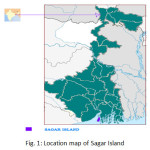 |
Figure 1: Location map of Sagar Island. Click here to View figure |
Hydrogeology
Sagar Islands is underlain by recent alluvium of clay, silt and sand deposited by river Ganga. Fresh group of aquifers occur within depth span of 205 – 325 m bgl and overlain by saline group of aquifers. Fresh ground water occurs under confined condition. Piezometric level varies from 3.58 to 5.09 m bgl and from 3.10 to 5.78 m bgl in pre-monsoon and post-monsoon period respectively. Deep tube wells are tapping fresh water bearing zones within the depth range of 245 to 325 m bgl (Anon, 2005).
Source of Water Supply in the Islands
Main source of domestic supply in the Islands is ground water. There are six Government owned deep tube wells rendering piped ground water supply to the few villages. Numbers of functioning tube wells are 685. Average number of households per tube well in the Island is 72.44. In the areas having no tube wells are depending on pond water for drinking. River water is saline due to tidal effect and not fit domestic purpose. Rainwater stored in ponds, tanks and canals are only sources of irrigation. There are no River Lift Irrigation, Shallow Tube Well and Deep Tube Well are operational as irrigation sources.
Problems in Ground Water Development
Fresh ground water occurs at deeper level, so exploitation of ground water is expensive for common people. Moreover, recharge to deeper aquifer is not feasible in the present hydrogeological set up. Deep tube wells are very less in number to meet the drinking and domestic water demand. Shallow tube wells are saline/brackish and are not suitable for drinking. Irregular electric supply is the hindrance and expensive to withdraw ground water. Alternate source of solar energy is insufficient.
Salinity Problem
To understand the suitability of groundwater and surface water quality of Sagar Island for irrigation purposes, it must be mentioned that the observations have been made on single set of water samples collected during February, 2012 with the presumptions that the sample was fully representative of hydro chemical conditions of the area. The nature and concentration of dissolved constituents in ground water showed not only the spatial but temporal variations also. Although it was generally presumed that quality of ground water did not show marked changes as in surface waters.
In the study area of Sagar groundwater samples analysed 100% were found to have high salinity having EC from 750μs/cm to 2250μs/cm. Such waters require adequate drainage, special management for salinity control to grow plants of good salt tolerance. These type of waters are not fit for irrigation under ordinary conditions, but may be occasionally used under very special conditions with adoption of appropriate technologies. Artificial drainage is a costly affair and is not recommended. However, such waters may be safely used by blending with good quality surface water where-ever available for use as irrigation purpose.
Discussion
Detailed survey has been conducted in the Sagar Island of South 24 Parganas district of West Bengal State to understand the scope of rainwater conservation through concreted roof tops and household small ponds. This study is aiming at to calculate the amount of rain water that can be conserved from the existing concrete roof tops and household small ponds and their contribution towards the drinking and domestic water demand during lean period. In view of the above, details of existing concrete (pacca) buildings with cemented roof tops and household ponds (Fig. 2) have been collected, where from rainwater could be harvested during monsoon period. With respect to 1991 census, growth rate of population has been increased to 20.38% in 2001census, whereas in comparison to 2001 census growth rate of population has been raised to 14.20 % in 2011 census (Anon,2001).
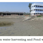 |
Figure 2: Roof top rain water harvesting and Pond water conservation. Click here to View table |
This roof top rain water conservation during monsoon would play dual roles namely i) will help to minimize the wastage of rainwater through surface run-off and ii) would be useful during non-monsoon periods especially for domestic, drinking and house surrounding growing vegetable crops wherever irrigation water required.
At present, total water requirement of Sagar Island in peak summer (4-5 months) for drinking and domestic uses is around 1589947.50 cu. m. Total amount of rainwater could be conserved through small household ponds (12418) and concrete roof tops (3194) was 3692853 cu m of which ponds could contribute 3588976 cu m water and concrete roof tops could contribute 10,38,77 cu m water. Thus, this conserved rain water would able to cater the need of 492380 people (i.e., more than double of present population) of Sagar Island for five months in peak summer for drinking and domestic uses.
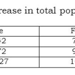 |
Table 1: Census wise rate of increase in total populations. Click here to View table |
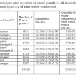 |
Table 2: Gram Panchayet wise number of small ponds in all households along with their dimensions and quantity of rain water conserved. Click here to View table |
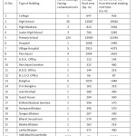 |
Table 3: Details of existing concrete buildings (approx.) with average roof area and total rain water can be conserved. Click here to View table |
Acknowledgements
The author(s) duly acknowledge the assistance provided by the Regional Director, Central Ground Water Board for Eastern Region, Kolkata and thankful for given permission in carrying out the work in collaboration with Bidhan Chandra Krishi Viswavidyalaya, West Bengal.
References
- Anon (1984). Report on Soil Survey Report of Sagar Island, District 24 Parganas, West Bengal, NBBSLUP, Regional Office, Kolkata; November,1984.
- Anon (1986). Proceedings of National Seminar on problems and Management of Coastal Systems; (Dec. 29 – 31, 1986); Indian Society of Coastal Agricultural Research; Canning Town, West Bengal
- Anon (1994). Hydrogeology and Ground Water Resources of South 24 Parganas District, West Bengal (Eastern Region, Calcutta; September, 1994).
- Anon (2001). Hydrogeology of Sundarban Area, West Bengal; Central Ground Water Board, Eastern Region, Kolkata; June, 2001.
- Anon (2001). Report on PHED, Government of West Bengal, 2001; Village Pond water supply arrangement for Dayapur Mouza (2nd Phase), Gosaba Block, South 24 Parganas district, Unpublished.
- Anon (2002). Report on District Statistical Hand Book; 2002; South 24 Parganas, Bureau of Applied Economics and Statistics, Govt. of West Bengal.
- Anon (2004). Ground Water Year Book of West Bengal (2003–2004); July, 2004; Central Ground Water Board, Eastern Region, Kolkata.
- Anon (2005a). Administrative Report, 2004-2005, Sundarban Development Board, Sundarban affairs Department, Government. of West Bengal
- Anon (2005b). Report on Ground water management study in southern parts of South 24 Parganas district (AAP 2004-05)
- Anon (2005c). Proceedings of Workshop–cum-Seminar on Embankments of Sundarbans and related issues; 21st July, 2005;
- Anon (2005d). Report on Ground water management studies in Southern part of South 24 Parganas district (AAP:2004–2005)