


 PDF Downloads:
208
PDF Downloads:
208


Introduction
Soil moisture availability plays an important role in determining water status of crops, the efficiency of irrigation, and agricultural production.1,2 In semi-arid Karnataka, India, where more than 60% of the farmland is rainfed, accurate knowledge about soil moisture content can help decrease the water stress on crops without any extra expenses related to irrigation. Ragi (finger millet, Eleusine coracana G.) is the most important dryland cereal grown in Karnataka, and its cultivation is common in the red lateritic regions of Hassan, Tumkur, Kolar, and Mandya. These districts produce about 50% of the total ragi production in India. However, even in drought-resistant plants like ragi, crop yield losses up to 50% happen if Percent Available Soil Moisture(PASM) drops below 58% of the field capacity.
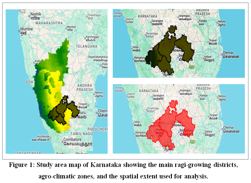 |
Figure 1: Study area map of Karnataka showing the main ragi-growing districts, agro-climatic zones, and the spatial extent used for analysis. |
Soil moisture in the root zone (RZSM) of ragi, computed using integration over the rooting depth of 20 to 60 centimetres, is the important parameter for irrigation scheduling from an agronomic perspective. Traditional approaches using gravimetric sampling and capacitance probes at point locations are impractical for scaling to a district level due to their limited spatial extent and high labour requirements.1,2 The availability of free data archives of satellites including Soil Moisture Active Passive(SMAP) Level-4 RZSM, Sentinel-1 C-BandSynthetic Aperture Radar (SAR), Sentinel-2 multi-spectral imagery, ERA5-Land reanalysis, CHIRPS precipitation, and SoilGrids soil texture has made large-scale estimation of RZSM possible through the use of ensemble machine learning algorithms.3,4 None of the existing operational DSSs has applied these data streams to produce stage-wise irrigation advice for ragi farmers in Karnataka. The objective of this review is to (i) consolidate remote sensing and machine learning approaches relevant for RZSM assessment, (ii) evaluate their appropriateness for application on Karnataka’s laterite soils and monsoon climate conditions, (iii) pinpoint important research challenges and gaps and (iv) propose a research framework for the open data based ragi irrigation DSS.
Ragi is considered to be one of the most nutritionally important millets across the globe and forms an integral part of the diet of rural population in South India. The state of Karnataka accounts for about 50% of the total production of ragi in India and is mainly grown in Southern Dry Zone (Zone 5) and Central Dry Zone (Zone 3), which have southwest monsoon rains ranging from 700 to 900 mm/year, with red lateritic Alfisols having high infiltration rate and low water holding capacity. Shivaramu et al.5determined stage specific PASM-yield response curves for ragi in Karnataka, showing that yield reduction is more than 50%, if PASM levels fall below 58% in tillering (25-40 DAYS), panicle initiation (45-60 DAYS), and grain filling (65-80 DAYS) stages.
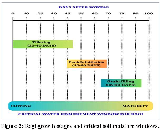 |
Figure 2: Ragi growth stages and critical soil moisture windows. |
Areas Covered
The review adhered to the Preferred Reporting Items for Systematic Reviews and Meta-Analyses(PRISMA) guidelines. A systematic literature search was performed using the databases Google Scholar and IEEE Xplore from January 2018 through December 2025. Four search terms related to the topic areas were: ML-based estimation of RZSM, SAR-based irrigation studies, satellite-based crop management support systems, and finger millet water stress. The search results totalled 8,602 papers (8,578 Google Scholar, 24 IEEE Xplore). After the deduplication process (~1,200 unique papers), title and abstract screening filtered down to 180 papers, 60 were eligible at the full paper level. Ultimately, 20 papers meeting all inclusion criteria were selected from IEEE, Elsevier, MDPI, Springer, and Taylor & Francis. The inclusion criteria included: remote sensing data obtained by satellites (SMAP, Sentinel-1/2, ERA5 or alike), a machine learning approach, English language, and agricultural soil moisture or irrigation management-related topics.
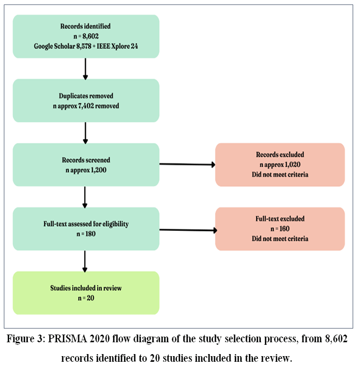 |
Figure 3: PRISMA 2020 flow diagram of the study selection process, from 8,602 records identified to 20 studies included in the review. |
The reviewed studies draw on a common set of open access satellite and climate datasets, summarized later in Table-1 and apply a range of machine learning approaches described below.
Body
Machine Learning Approaches for Soil Moisture Estimation
Three generations can be identified in the development of soil moisture estimation through satellite remote sensing techniques: physics-based land surface models (Richards equation, Hydrus-1D), semi-empirical SAR inversion (Water Cloud Model, TU Wien change detection), and machine learning (ML) approaches based on feature stacks from multi-source satellites.1,2In the category of machine learning algorithms, the ensemble of tree models is now the prevalent technique used for the estimation of RZSM. In particular, the Random Forest (RF) model creates several decision trees based on samples of the training set and aggregates their predictions, thus avoiding overfitting and being able to effectively deal with non-linearities between the satellite variables and soil moisture. The other model worth considering is the eXtreme Gradient Boosting (XGBoost), which builds trees in sequence and with each new tree tries to improve on the mistakes made by the previous one, thus providing better predictive performance at the cost of a more tedious hyperparameter tuning.The most recent and comprehensive review is by Lamichhane et al.6 demonstrating the rise of the use of ensembles of trees and hybrids of ML algorithms, which outperform single sensor-based methods whenever multi-source feature stacks are used. According to their review, Random Forest and XGBoost algorithms provide the best compromise between accuracy and complexity.Moreover, Li et al.7have made an attempt to categorize the RZSM estimation methods based on their nature, which can be divided into four different categories, such as empirical, semi-empirical, physics-based, and machine learning models.
The quantitative benchmarks from recently conducted studies help to set up the benchmark. Lakra et al.,3 obtained Random Forest (RF) training R² = 0.88 for Indian agricultural lands using Sentinel-1 SAR. However, R² for validation fell down to 0.61 and indicated the problem of spatial overfitting, which is an extremely important one for Karnataka’s implementation. Tola et al.4demonstrated R² = 0.89 using a hybrid ML approach based on SMAP, Integrated Multi-satellitE Retrievals for GPM(IMERG) and Sentinel-1 data fusion at 100 m resolution for US agricultural lands. Settu and Ramaiah,8 revealed that ,gradient-boosted stacking ensembles and neural network residual correction provided the best generalisation for different land covers. Batchu et al.9 proposed the convolutional-regression fusion deep learning model based on Sentinel-1/2, SoilGrids, SMAP and Global Land Data Assimilation System(GLDAS) and obtained the global unbiased Root Mean Square Error(ubRMSE) equal to 0.055 m³/m³ at 320 m resolution.
However, comparing the two studies shows a trend whereby the methods which have been verified on diverse environments, such as those by Tola et al.4using a combination of satellite fusion in varied U.S. agricultural lands (R² = 0.89) show better results in stability in train-validation than single region studies with fewer feature sets (for instance, by Lakra et al.3which shows a reduction in R² value from 0.88 to 0.61 in training and validation) showing that the possibility of spatial overfitting is negatively correlated with the diversity of the environment trained, an issue which must be considered in any specific Karnataka method implementation due to the unique lateritic Alfisols soil-climate conditions.
SAR-Based Retrieval and SMAP Downscaling
Sentinel-1 C-band SAR (σ⁰VV, σ⁰VH) is now considered the benchmark for active sensing for surface soil moisture retrieval, thanks to its all-weather feature and 6-day revisit.2,9The Soil Moisture Active Passive (SMAP) mission by NASA uses a combined technique of L-band radiometer and (initially) radar to retrieve soil moisture information; its Level-4 data assimilate the passive microwave data into a land surface model for estimation of surface and root-zone soil moisture with 9 km spatial resolution in every 3 days. Since L-band passive microwave data are highly insensitive to any atmospheric and moderate vegetation noise, SMAP L4 is widely recognized as the nearest available proxy of ground truth RZSM at coarse scale, which is the very reason why many literature works mentioned here (see Table 1) have been devoted to downscaling of it via high-resolution active remote sensing methods.Hoskera et al.10 conducted a detailed evaluation of semi-empirical SAR models (Oh, Dubois, Water Cloud) in Indian croplands and showed the decrease in model accuracy when Normalized Difference Vegetation Index(NDVI) surpasses 0.4 – a usual case during Karnataka’s kharif ragi period. Zhang et al.11 introduced a Google Earth Engine based soil moisture estimation framework of 60m resolution combining Sentinel-1 VV/VH and Sentinel-2 multispectral data.However, in another separate study, Lamichhane et al.12assessed four ML models (SVM, RF, GBM, and KNN) for estimating surface soil moisture from Sentinel-1 SAR data in combination with Harmonized Landsat-Sentinel satellite data at 10 m spatial resolution for maize, wheat, and millet farms in semi-arid Colorado, USA. In this particular case, the GBM model yielded the highest accuracy with an R² value of 0.72. It should be noted that comparatively low accuracy compared to other studies cited in this review shows the dependency of SSM estimation on the type of crop and its growth stage.
The issue is particularly relevant in the case of Karnataka: the 1D-CNN model proposed by Hegazi et al.13with its R²=0.82, as well as the GBM-based comparison performed by Lamichhane et al.12 with its lowest R²=0.72 in this review, were carried out in dryland or semi-arid farming systems very much like those of the kharif ragi crops, while more accurate studies like that of Zhang et al.11 with their 60m Google Earth Engine approach (without specific reports on NDVI performance) did not include information on the accuracy in relation to high NDVI vegetative cover.
The downscaling of SMAP data from 9 km to field-level resolution is the primary technical issue in RZSM irrigation applications. Meyer et al.14 performed sub-kilometre SMAP-Sentinel-1 downscaling with vegetation-dependent algorithm parameters, and it was found that VV and VH backscatter are highly correlated with in-situ SM at 20-400 m scale range. Cui et al.15 incorporated vegetation memory as a spatiotemporal fusion factor for SMAP downscaling in monsoon dry spell periods, and it will be important in the context of Karnataka’s sporadic rainfall. Mahmood et al.16 downscaled SMAP data to 100 m RZSM using 1 km Soil Water Index datasets along with terrain, soil texture, and Normalized Difference Vegetation Index(NDVI) using ML.The latest work on downscaling SMAP soil moisture is that conducted by Sang et al.17 in which five machine learning algorithms such as Support Vector Regression, eXtreme Gradient Boosting, Random Forest, Deep Neural Networks, and Stacking have been used for downscaling SMAP soil moisture at a scale of 9 to 1 km through multimodal data fusion with the Random Forest model giving the best results (R²=0.92) and validating the results with CHIRPS precipitation dataset.
Of all these approaches, the one used by Meyer et al.14 whereby there was high correlation between the VV/VH backscatter and in situ soil moisture at the 20-400 m scale, is the most applicable in the case of Karnataka’s smallholder ragi fields, which are smaller compared to the original scale of SMAP products (9 km). The use of vegetation memory in Cui et al.15 is highly applicable owing to the fact that there are dry spells in the case of the Karnataka monsoons.
Open-Access Satellite Data for RZSM in Karnataka
Table 1 summarizes the key open-access datasets used across the machine learning and SAR based approaches discussed above.
Table 1: Open-Access Datasets For Rzsm Estimation In Karnataka
|
Dataset |
Source |
Variable |
Relevance |
Resolution |
|
Soil Moisture Active Passive(SMAP) L4 |
NASA |
RZSM 0-100 cm, surface SM1,4,9,14-16, |
Ground truth proxy, RZSM baseline |
9 km, 3-day |
|
Sentinel-1 |
ESA |
SAR backscatter σ⁰VV, σ⁰VH3,4,9-14, |
Surface SM, cloud-penetrating |
10-20 m, 6-day |
|
Sentinel-2 |
ESA |
Normalized Difference Vegetation Index(NDVI), Enhanced Vegetation Index(EVI), Leaf Area Index(LAI)9,11 |
Crop health, vegetation dynamics |
10-20 m, 5-day |
|
ERA5-Land |
ECMWF |
Temperature, Evapotranspiration(ET), precipitation17 |
Climatic forcing, soil drying |
9 km, hourly |
|
Climate Hazards Group InfraRed Precipitation with Station data (CHIRPS) |
UCSB/USGS |
Daily rainfall estimates17 |
Antecedent rainfall for ragi fields |
5.5 km, daily |
|
SoilGrids DEM |
ISRIC |
Clay, Organic Carbon, bulk density9 |
Soil hydraulic properties, Water Holding Capacity(WHC) |
250 m, static |
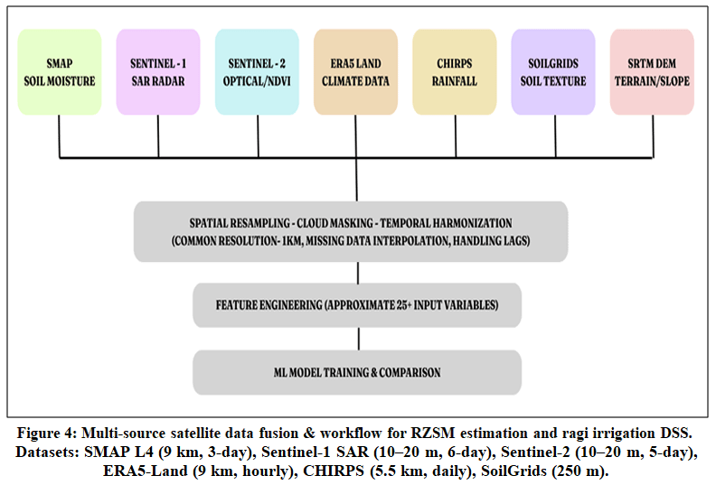 |
Figure 4: Multi-source satellite data fusion & workflow for RZSM estimation and ragi irrigation DSS. Datasets: SMAP L4 (9 km, 3-day), Sentinel-1 SAR (10–20 m, 6-day), Sentinel-2 (10–20 m, 5-day), ERA5-Land (9 km, hourly), CHIRPS (5.5 km, daily), SoilGrids (250 m). |
Root Zone Depth Extension and DSS Development
ERA5-Land, which is the ECMWF land surface reanalysis at hourly time steps and 9 km resolution, and CHIRPS, which is the UCSB/USGS satellite and gauge-based rainfall data product at daily time step and 5.5 km resolution, are the climatic forcings required for depth extrapolation, while SoilGrids (ISRIC’s global soil property map at 250 m resolution) provides the soil properties used in controlling the movement of surface water into root zone. Depth extrapolation from surface layer of measurements (0-5 cm) to root zone layer (20-60 cm for ragi) requires an explicit depth extrapolation algorithm.For instance, Stefan et al.1 have developed exponential filter (EF) calibration per land cover type based on SMAP data, obtaining Root Mean Square Error(RMSE) of 0.04-0.06 m³/m³ for estimating RZSM – the most relevant depth extrapolation technique for the case study in question with regard to Karnataka’s data-poor setting. Yinglanet al.18 employed ConvLSTM with MODIS NDVI and ERA5 climate forcing to obtain RZSM at 40 cm depth (R²=0.60 compared to the baseline R²≈0.02 with GLDAS) and thereby validated the importance of integrating the temporality of vegetation-climate relationship in order to obtain proper depth extrapolations. On the other hand, Zha et al.19 took the complementing path, using the combination of a Random Forest model to derive high-resolution (1 km) near-surface soil moisture from ground station observations in an agricultural area susceptible to drought conditions, followed by the physics-based Richards equation with the near-surface value as the upper boundary condition to compute multi-depth root-zone soil moisture with an R value ranging from 0.97 at 10 cm to 0.43 at 100 cm depth.Kisekka et al.20 have shown field-scale spatial-temporal ML modelling of root zone SM dynamics using remote sensing, which proves that stacking of multi-temporal SAR and optical features yields much higher depth estimation accuracy compared to single-date methods. Babaeianet al.21have integrated ground, Unmanned Aerial Vehicle(UAV), and satellite data with the help of automated ML with R²>0.90. However, their reliance on in-situ arrays makes this technique not feasible without adaptations for Karnataka.Among all these, the method developed by Stefan et al.1, the exponential filter, is the most practical to implement in Karnataka since it uses only a little amount of data, compared to the deep learning techniques of Yinglan et al.18and Babaeian et al.21 that are highly accurate but require inputs.
On the DSS end, the most operationally realistic precedence is set by Roy et al.22, who have developed a machine learning-based irrigation system for grape farmers in Nashik, Maharashtra. The system incorporates data from L-Band satellites in tandem with Internet-of-things (IoT) sensors and provides up to 17-45% savings in seasonal water usage. However, this system relies on an extensive network of sensors, which cannot be afforded by ragi smallholders. In their comprehensive analysis of remote sensing applications in precision agriculture, Sishodia et al.,2 noted the lack of irrigation advice systems tailored to specific crop’s root zone.
An analysis of the abovereviewed literature leads to the identification of five interrelated gaps that, combined together, hinder the design of an open-data, RZSM-based irrigation DSS for ragi production in Karnataka. The gaps along with the present state and suggested research directions have been outlined in Table 2.
Table 2: Research Gaps, Current Stateand Proposed Directions
|
Research Gap |
Current State |
Proposed Direction |
|
G1: No ragi-specific RZSM-DSS |
No operational open-data DSS exists for ragi in Karnataka |
Ensemble ML(Random Forest(RF)/eXtreme Gradient Boosting (XGBoost)/LightGBM) with open satellite data + published PASM thresholds |
|
G2: Root zone depth limitation |
Satellites measure 0-5 cm only, 20-60 cm estimation unvalidated in Karnataka |
Exponential filter + temporal ML with SAR, ERA5, and SoilGrids, calibrate per Karnataka soil class |
|
G3: Transferability without in-situ data |
High-accuracy systems require costly sensor networks unavailable in Karnataka |
Semi-supervised learning, domain adaptation using SMAP L4 and SoilGrids priors, spatial cross-validation |
|
G4: Inconsistent validation frameworks |
Heterogeneous metrics (R², Root Mean Square Error(RMSE), unbiased Root Mean Square Error(ubRMSE) prevent cross-study comparison |
Adopt SMAP-standard ubRMSE, spatial block k-fold validation, leave-one-district-out testing |
|
G5: Absence of forecast integration |
Existing systems estimate current SM, no 7-14 days irrigation forecast available |
Couple ML-based RZSM dynamics with ERA5 ensemble or India Meteorological Department(IMD) short-range forecasts for proactive advisories |
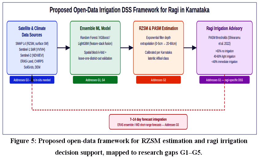 |
Figure 5: Proposed open-data framework for RZSM estimation and ragi irrigation decision support, mapped to research gaps G1–G5. |
Gap G1 constitutes the key operational gap: PASM yield threshold for ragi is publicly available,5freely available satellite data can be found,3,4,6,8,9,17 ensemble machine learning approaches have been developed and tested,3,4,8,9,17. However, there is still no system that would integrate these elements into irrigation recommendations. Gap G2 is technical and builds upon Gap G1: due to the fact that in Karnataka Alfisols of lateritic class are prevailing, which possess high infiltration rates and low water-holding capacity, exponential filtering parameterisation developed for the temperate soil may prove to be inadequate. Gaps G3 and G4 challenge model transferability: lack of spatial validation procedures and in-situ-free calibration approaches makes reliability claims for non-Karnataka data doubtful.
Conclusion
In this review, based on PRISMA 2020, twenty peer-reviewed articles published between 2018 and 2025 have been analyzed that discuss satellite-based estimates of Root-Zone Soil Moisture (RZSM) and irrigation using machine learning, especially concerning ragi crops in Karnataka. It is observed from the reviewed literature that machine learning ensemble models, specifically the Random Forest, eXtreme Gradient Boosting (XGBoost), and LightGBM algorithms, when trained on fused datasets from multiple sources consisting of satellites and weather stations like SMAP, Sentinel-1, Sentinel-2, ERA5-Land, CHIRPS, and SoilGrids, are highly accurate in their predictions of soil moisture with several studies having R² more than 0.85. Multi-resolution downscaling of SMAP soil moisture data with the help of Sentinel-1 SAR with depth extrapolation techniques such as the exponential filter has proven to be a successful strategy for linking satellite-based surface soil moisture and RZSM estimates.However, in the context of this review, there have been identified five interlinked gaps that at the moment prevent the use of these techniques in developing such an irrigation advice generation tool for ragi cultivation in Karnataka, India. They are absence of ragi-based decision support systems (DSS), unsolved issue of extrapolation of soil depths of Karnataka’s lateritic Alfisols, lack of transferability of models without in situ calibration, inconsistency of validation procedures in different papers, and lack of ability to include forecast into the model. It seems quite likely that filling all these gaps together through the ensemble of machine learning algorithms, calibrated by the help of Percent Available Soil Moisture (PASM) yield thresholds, proper validation on the block level, and including weather forecast into the model can be considered as a feasible way of developing an irrigation advice generation tool based on open data and scaled. This research work is being carried out right now.
Acknowledgement
I would like to express my heartfelt gratitude to the Almighty and to my parents Chandrasan.A & Bhavani.K for their blessings and constant support. I also express my sincere gratitude to my Research Guide, Dr. Solomon Jebaraj, Associate Professor, Department of CSIT, JAIN (Deemed-to-be University), Bengaluru, Karnataka, India, for his invaluable guidance and support throughout the course of this research.
Funding Sources
The author(s) received no financial support for the research, authorship, and/or publication of this article.
Conflict of Interest
The authors declare that they have no conflict of interest.
Data Availability Statement
This statement does not apply to this article, public dataset used.
Ethic Statement
This research did not involve human participants, animal subjects, or any material that requires ethical approval.
Informed Consent Statement
This study did not involve human participants, and therefore, informed consent was not required.
Clinical Trial Registration
This research does not involve any clinical trials.
Permission to Reproduce Material From Other Sources
Not Applicable
Author Contributions
- Bhavya Chandrasan: Conceptualization, Methodology, Data Collection, Analysis, Writing – Original Draft.
- Solomon Jebaraj: Supervision & Editing.
References
- Stefan VG, et al. High-resolution SMAP-derived root-zone soil moisture using an exponential filter model calibrated per land cover type. Remote Sens. 2021;13(6):1112. doi:10.3390/rs13061112
CrossRef - Sishodia RP, Ray RL, Singh SK. Applications of remote sensing in precision agriculture: a review. Remote Sens. 2020;12(19):3136. doi:10.3390/rs12193136
CrossRef - Lakra D, et al. Soil moisture retrieval over agricultural region through machine learning and Sentinel-1 observations. Front Remote Sens. 2024;5:1513620. doi:10.3389/frsen.2024.1513620
CrossRef - Tola D, et al. High spatial resolution soil moisture mapping integrating SMAP, IMERG, and Sentinel-1 in machine learning models. Remote Sens. 2025;17(13):2129. doi:10.3390/rs17132129
CrossRef - Shivaramu HS, et al. Soil moisture induced yield variability in major crops of Karnataka. Indian J Agric Sci. 2022;92(7):836-841. doi:10.56093/ijas.v92i7.104382
CrossRef - Lamichhane M, Mehan S, Mankin KR. Soil moisture prediction using remote sensing and machine learning algorithms: a review. Remote Sens. 2025;17(14):2397. doi:10.3390/rs17142397
CrossRef - Li B, Sun H, Zhao R. A review of root zone soil moisture estimation methods based on remote sensing. Remote Sens. 2023;15(22):5361. doi:10.3390/rs15225361
CrossRef - Settu P, Ramaiah M. A data driven comparison of hybrid machine learning techniques for soil moisture modeling using remote sensing imagery. Sci Rep. 2025;15:4321. doi:10.1038/s41598-025-27225-0
CrossRef - Batchu V, Nearing G, Gulshan V. A deep learning data fusion model using Sentinel-1/2, SoilGrids, SMAP, and GLDAS for soil moisture retrieval. J Hydrometeorol. 2023;24(10):1789-1823. doi:10.1175/JHM-D-22-0118.1
CrossRef - Hoskera AK, et al. Accuracies of soil moisture estimations using a semi-empirical model over bare soil agricultural croplands from Sentinel-1 SAR data. Remote Sens. 2020;12(10):1664. doi:10.3390/rs12101664
CrossRef - Zhang Z, et al. An automated method for regional-scale agricultural soil moisture retrieval using ISMN measurements and Sentinel data in Google Earth Engine. IEEE J Sel Top Appl Earth Obs Remote Sens. 2026;19:1856-1871. doi:10.1109/JSTARS.2025.3642244
CrossRef - Lamichhane M, Mehan S, Mankin KR. Surface soil moisture prediction using multimodal remote sensing data fusion and machine learning in semi-arid agricultural region. Sci Remote Sens. 2025;12:100255. doi:10.1016/j.srs.2025.100255
CrossRef - Hegazi EH, Yang L, Huang J. A convolutional neural network algorithm for soil moisture prediction from Sentinel-1 SAR images. Remote Sens. 2021;13(24):4964. doi:10.3390/rs13244964
CrossRef - Meyer R, et al. Exploring the combined use of SMAP and Sentinel-1 data for downscaling soil moisture beyond the 1 km scale. Hydrol Earth Syst Sci. 2022;26:3337-3357. doi:10.5194/hess-26-3337-2022
CrossRef - Cui C, et al. A spatial downscaling method for SMAP soil moisture considering vegetation memory and spatiotemporal fusion. Int J Digit Earth. 2024. doi:10.1080/17538947.2024.2367729
CrossRef - Mahmood T, et al. Estimation of 100 m root zone soil moisture by downscaling 1 km soil water index with machine learning and multiple geodata. Environ Monit Assess. 2024;196(9):12969. doi:10.1007/s10661-024-12969-5
CrossRef - Sang X, Lu X, Wang K, Zhou J, Cai G, Fan J. SMAP soil moisture downscaling via multimodal data fusion and machine learning. Earth Syst Environ. 2026;10(6):7833-7852. doi:10.1007/s41748-026-01031-8
CrossRef - Yinglan A, et al. Root-zone soil moisture estimation based on remote sensing data and deep learning. Environ Res. 2022;212:113278. doi:10.1016/j.envres.2022.113278
CrossRef - Zha X, Jia S, Han Y, Zhu W, Lv A. Enhancing soil moisture prediction in drought-prone agricultural regions using remote sensing and machine learning approaches. Remote Sens. 2025;17(2):181. doi:10.3390/rs17020181
CrossRef - Kisekka I, et al. Spatial-temporal modeling of root zone soil moisture dynamics in a vineyard using machine learning and remote sensing. Irrig Sci. 2022;40(4-5):761-777. doi:10.1007/s00271-022-00775-1
CrossRef - Babaeian E, et al. Estimation of root zone soil moisture from ground and remotely sensed soil information with multisensor data fusion and automated machine learning. Remote Sens Environ. 2021;261:112482. doi:10.1016/j.rse.2021.112482
CrossRef - Roy A, et al. Remote sensing and climate services improve irrigation water management at farm scale in Western-Central India. Sci Total Environ. 2023;879:163003. doi:10.1016/j.scitotenv.2023.163003
CrossRef
Abbreviations
RZSM-Root-Zone Soil Moisture
PASM-Percent Available Soil Moisture
DSS-Decision Support System
ML-Machine Learning
PRISMA-Preferred Reporting Items for Systematic Reviews and Meta-Analyses
SMAP-Soil Moisture Active Passive
SAR-Synthetic Aperture Radar
CHIRPS-Climate Hazards Group InfraRed Precipitation with Station data
WHC-Water Holding Capacity
OC-Organic Carbon
NDVI-Normalized Difference Vegetation Index
EVI-Enhanced Vegetation Index
LAI-Leaf Area Index
ET-Evapotranspiration
RF-Random Forest
XGBoost-eXtreme Gradient Boosting
CNN-Convolutional Neural Network
ConvLSTM-Convolutional Long Short-Term Memory
RMSE-Root Mean Square Error
ubRMSE-unbiased Root Mean Square Error
GLDAS-Global Land Data Assimilation System
IMERG-Integrated Multi-satellitE Retrievals for GPM
ISMN-International Soil Moisture Network
MODIS-Moderate Resolution Imaging Spectroradiometer
IoT-Internet of Things
EF-Exponential Filter
IMD-India Meteorological Department
UAV-Unmanned Aerial Vehicle