


 PDF Downloads:
202
PDF Downloads:
202


Introduction
Rice (Oryza sativa L.) is one of the most important food crops in India and plays a critical role in food security, rural livelihoods, agricultural employment, and public food procurement. The spatial distribution of rice cultivation is traditionally associated with favourable rainfall, assured water availability, suitable soils, and irrigation infrastructure. In semi-arid regions, however, the expansion of water-intensive crops such as rice is increasingly shaped not only by agro-climatic suitability but also by public investment in irrigation, agricultural support policies, market incentives, and institutional arrangements. Consequently, changes in rice cultivation need to be understood as part of a broader socio-ecological transformation rather than merely as changes in the cropped area.
Telangana provides a particularly important setting for examining this transformation. Much of the state is characterised by semi-arid climatic conditions, high rainfall variability, recurrent moisture stress, and historically heterogeneous access to irrigation. Prior to the recent expansion of irrigation infrastructure, intensive rice cultivation was relatively concentrated in established irrigated belts, particularly in districts benefiting from canal, tank, and groundwater resources. Rainfed crops, including pulses, oilseeds, cotton, maize, and coarse cereals, occupied an important position in several relatively water-constrained areas. The spatial organisation of agriculture, therefore, broadly reflects differences in water availability, agro-ecological conditions, and access to irrigation.
Following the formation of Telangana State in 2014,the government directed substantial public investment towards strengthening and expanding irrigation infrastructure. Large-scale interventions, including the Kaleshwaram Lift Irrigation Scheme, restoration of traditional tanks under Mission Kakatiya, expansion of lift-irrigation systems, and improvement of existing irrigation networks, altered the availability and spatial distribution of agricultural water. These interventions coincided with institutional support for rice through Minimum Support Price (MSP) and public procurement mechanisms. Together, improved water access and economic incentives created favourable conditions for the expansion and intensification of rice cultivation beyond its traditional production belts.
This transformation has an important spatial and seasonal dimension. Rice cultivation has expanded into several districts that were previously characterised by relatively low rice intensity and a greater dependence on rainfed agriculture. At the same time, assured irrigation has facilitated substantial expansion of Rabi rice, resulting in increasingly intensive and, in some locations, near year-round rice-based production systems. The process therefore represents more than an increase in cultivated area; it indicates a restructuring of the relationship between irrigation infrastructure, cropping decisions, agricultural policy, and agro-ecological conditions. Such changes may improve production stability, marketable surplus, farm income, and food-grain procurement, but they may also generate ecological trade-offs through increasing water demand, groundwater pressure, nutrient depletion, soil degradation, and displacement of less water-intensive crops.
These developments raise a broader sustainability question for semi-arid agricultural regions. The expansion of an irrigation-dependent and water-intensive crop into agro-ecologically diverse environments can reduce the correspondence between traditional cropping systems and local resource endowments. Continued rice intensification may therefore create a tension between short-term production and income benefits and the long-term objectives of water security, crop diversification, climate resilience, and sustainable land management. Understanding where this transformation is occurring, how rapidly it is taking place, and whether it differs across agro-ecological settings is essential for designing geographically differentiated agricultural policies.
Despite the growing policy and academic interest in Telangana’s irrigation development and increasing rice production, an important research gap remains. Existing assessments commonly examine irrigation development, agricultural production, procurement, or cropping patterns independently and frequently rely on state-level aggregates. Comparatively less attention has been given to quantifying the district-level spatial redistribution of rice cultivation between contrasting periods while simultaneously distinguishing Kharif and Rabi cultivation, irrigated and unirrigated areas, and differences among Agro-Ecological Zones (AEZs). Consequently, the extent to which irrigation-led development has transformed the geography and seasonality of rice cultivation across Telangana remains insufficiently documented.
The present study addresses this gap through a comparative spatio-temporal assessment of district-wise rice cultivation using the triennium averages of 2016–18 and 2022–24. The analysis integrates temporal change, seasonal composition, irrigation dependency, district-level growth, statistical significance, and agro-ecological differentiation to identify established and emerging rice-intensive regions. In doing so, the study conceptualises the recent expansion of rice not simply as agricultural growth but as an irrigation-mediated socio-ecological transition in Telangana’s cropping landscape.
Research Objectives: The specific objectives of the study are: (i) to quantify district-level changes in the area under rice cultivation between 2016–18 and 2022–24; (ii) to assess the relative contribution of irrigated and unirrigated areas and Kharif and Rabi seasons to the observed expansion; (iii) to identify the spatial redistribution of rice cultivation across the Northern, Central, and Southern Agro-Ecological Zones of Telangana; (iv) to statistically evaluate the magnitude, variability, and significance of changes in rice area across districts; and (v) to examine the implications of irrigation-led rice intensification for crop diversification, water-resource dependency, and the long-term sustainability of agricultural systems in Telangana.
Review of literature/bibliographic context
Recent literature increasingly conceptualises agricultural transformation as an interaction among irrigation infrastructure, cropping decisions, market and policy incentives, agro-ecological conditions, and environmental resource constraints. In Telangana, this relationship has become particularly significant following the expansion of irrigated rice cultivation. Using geospatial techniques and Sentinel-2 satellite data, Panjala, Gumma and Mesapam1 documented a major shift towards rice within the Kaleshwaram Lift Irrigation Project command area and reported an increase of more than 80% in Rabi rice between 2018–19 and 2022–23, accompanied by substantial increases in crop-water requirements. Their findings provide independent remote-sensing evidence that recent changes in Telangana agriculture involve not merely an expansion of cultivated area but also a restructuring of cropping patterns and agricultural water demand. At the broader farming-system level, Saha, Bohra and Banjara2 emphasised diversification of rice-based systems with pulses, oilseeds, and high-value crops as a strategy for improving productivity, profitability, and sustainability. Similarly, Rautaray and Sucharita3 highlighted the ecological benefits of crop diversification and observed that assured markets and minimum support price incentives can contribute to the persistence of dominant crops such as rice. Mal and Chaudhary4 further demonstrated the importance of replacing water- and resource-intensive cereal systems with diversified cropping sequences for conserving irrigation water and maintaining soil health. Collectively, these studies suggest that Telangana’s recent rice expansion should be evaluated within a broader socio-ecological framework linking irrigation-induced agricultural transformation with spatial redistribution, seasonal intensification, water-resource demand, crop diversification, and long-term sustainability. The present study contributes to this literature by quantifying district-level changes between the trienniums 2016–18 and 2022–24 and examining their spatial, seasonal, irrigation, and agro-ecological dimensions.
Study Area
The study was conducted for Telangana State, India, covering its 33 districts and representing substantial variation in rainfall, irrigation availability, soil conditions, and cropping systems. For regional interpretation, the districts were grouped into the Northern, Central, and Southern Agro-Ecological Zones (AEZs). These zones provide an appropriate spatial framework for examining whether the recent expansion of rice cultivation represents a uniform state-wide phenomenon or a geographically differentiated transformation associated with irrigation availability and agro-ecological conditions.
Data Sources and Period of Analysis
The study used district-level secondary data on rice cultivation obtained from official agricultural statistical sources of the Government of Telangana, particularly the Directorate of Economics and Statistics and associated agricultural records.5,6 The variables considered were Kharif irrigated area, Kharif unirrigated area, total Kharif area, Rabi irrigated area, Rabi unirrigated area, total Rabi area, and annual total rice area, expressed in acres.
Two triennium periods, 2016–18 and 2022–24, were selected for comparative analysis. Three-year averages were preferred to individual-year observations to reduce the influence of short-term fluctuations caused by rainfall anomalies, temporary irrigation constraints, market conditions, and year-specific changes in cultivation. The two periods consequently provide relatively stable reference points for assessing medium-term structural changes in the spatial distribution of rice cultivation.
Statistical Analysis
Descriptive and inferential statistical techniques were used to quantify temporal and spatial changes in rice cultivation. For each period, the mean, standard deviation (SD), and coefficient of variation (CV) were calculated to characterise the central tendency and inter-district variability of rice areas. Absolute change and percentage change were estimated for each district to identify the magnitude and direction of temporal transformation.
Compound Annual Growth Rate (CAGR) was calculated to express the annualised rate of change between the two reference periods. Districts were subsequently ranked according to absolute and relative changes to identify established rice belts and newly emerging areas of rice intensification.
A paired-sample t-test was applied to evaluate whether the mean district-level rice area differed significantly between the two triennium periods. The null hypothesis (H₀) assumed no significant difference in mean district rice area between 2016–18 and 2022–24, whereas the alternative hypothesis (H₁) indicated a significant inter-period difference. Statistical significance was evaluated at conventional probability levels (p < 0.05 and p < 0.01).
Seasonal and Irrigation-Based Decomposition
To distinguish simple area expansion from changes in production structure, rice area was decomposed according to season (Kharif and Rabi) and irrigation status (irrigated and unirrigated). The relative contribution of each component to total rice area was calculated for both periods.
This decomposition enabled assessment of whether the observed expansion was predominantly associated with traditional monsoon-season cultivation or with the intensification of Rabi production under assured irrigation. The proportion of irrigated rice area was also examined to determine the extent to which the changing spatial distribution of rice cultivation was associated with increasing dependence on controlled water supply rather than rainfall alone.
Spatial Analysis and Spatial Autocorrelation
District-level data were integrated with the Telangana district boundary layer in a Geographic Information System (GIS) to examine the spatial distribution of rice cultivation and its temporal change. Comparable thematic maps were prepared for the two periods using consistent spatial units and classification procedures.
Empirical analysis of triennium averages (2016–18 and 2022–24) indicates a substantial expansion in rice area, driven primarily by large-scale irrigation interventions, including the Kaleshwaram Lift Irrigation Scheme and the Mission Kakatiya Tank Restoration Programme.
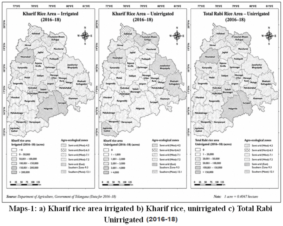 |
Maps 1: a) Kharif rice area irrigated b) Kharif rice, unirrigated c) Total Rabi Unirrigated (2016-18) |
The expansion is not merely incremental but statistically significant, with notable increases in both traditional and non-traditional rice-growing districts. Southern and central agro-ecological zones, which were previously semi-arid and dominated by rainfed crops, have experienced rapid intensification of irrigated rice cultivation. The increasing dominance of irrigated area, coupled with the expansion of Rabi rice, reflects improved water availability and strong procurement support under Minimum Support Price (MSP) policies.
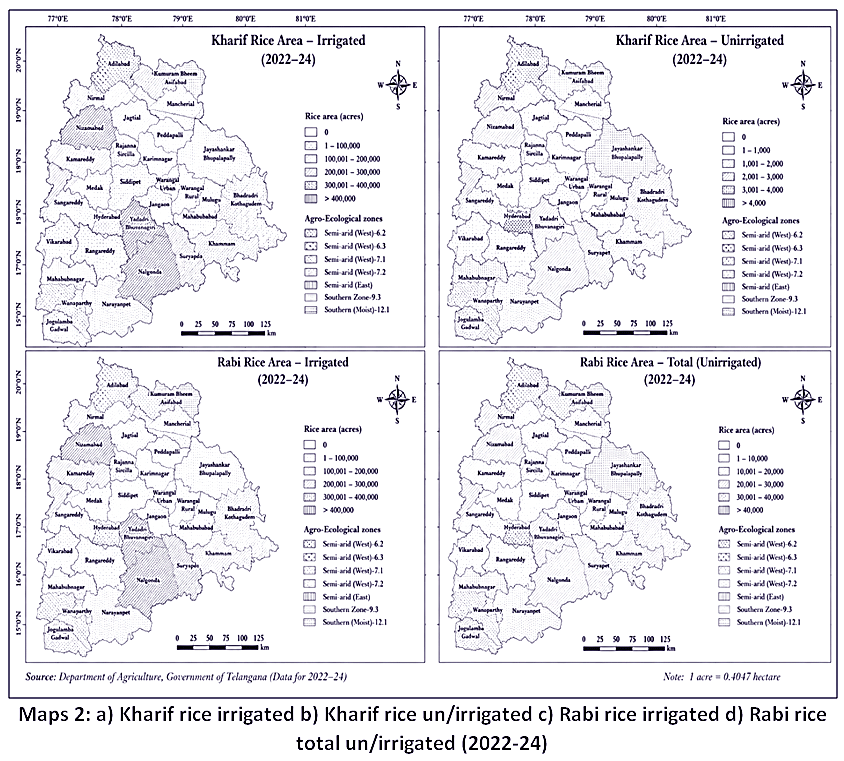 |
Maps 2: a) Kharif rice irrigated b) Kharif rice un/irrigated c) Rabi rice irrigated d) Rabi rice total un/irrigated (2022-24) |
While this growth has enhanced production stability, farmer incomes, and public grain procurement, it has also raised concerns regarding sustainability, including groundwater stress, reduced crop diversification, and long-term soil health implications. Therefore, the evolving rice economy of Telangana represents a dynamic interplay between irrigation expansion, policy incentives, agro-ecological adaptation, and structural transformation in cropping patterns.
Framework for Statistical Analysis Data Utilised: Period I
2016–18 triennium average and Period II: 2022–24 triennium average. Unit: Area in acres. Disaggregation: District-wise, Kharif, Rabi, Irrigated, Unirrigated, and Total. Descriptive Statistics: For both periods, mean area, the standard deviation (SD), the coefficient of variation (CV%), the absolute change (in acres), the percent change, and the share of irrigated vs. unirrigated area. Mean = ΣX / n, SD = √[Σ(X – X̄)² / n], CV = (SD / Mean) × 100, and % Change = [(Period II – Period I) / Period I] × 100
Analysis
Comparison of the triennium averages indicates a substantial increase in rice area between 2016–18 and 2022–24. The area of rice in Telangana increased substantially between the two reference periods. 2016–18 and 2022–24. The areas with irrigation predominantly exhibit this increase, indicating an improvement in irrigation practices, which is a sign of better irrigation infrastructure and policy support. According to Map-2, the averages for 2022–24 show that some districts recorded very large rice-growing areas: Nalgonda (more than 10 lakh acres), Suryapet (9.2 lakh acres), Nizamabad (8.4 lakh acres), Siddipet (7.3 lakh acres), and Jagtial (6.0 lakh acres). Telangana’smain rice-growing areas are in these districts.
Area with and without irrigation The data clearly indicate that rice cultivation is overwhelmingly irrigated in Telangana. In most districts, unirrigated rice areas are negligible. More than 95% of the total area in major districts is irrigated. This indicates the increasing influence of large-scale irrigation interventions, including the Kaleshwaram Lift Irrigation Scheme.Mission Kakatiya’s plan to restore tanks Assured MSP procurement promotes the expansion of paddy cultivation. The CV values go down in Period II, which means that rice farming is becoming more stable over time.
Seasonal Pattern (Kharif vs Rabi)
Rice area expansion is significant in both seasons, but traditionally Kharif dominated. Recent years have witnessed a marked increase in Rabi rice cultivation associated with improved irrigation availability. Districts such as Nalgonda, Suryapet, Nizamabad and Karimnagar show near parity between Kharif and Rabi areas, indicating year-round irrigation availability.
The rice cultivation area in Telangana is related to the Agro-Ecological Zones (AEZs)
AEZ 1
The Northern Telangana Zone Note: The Nizamabad, Jagtial, and Karimnagar belt has seen a lot of rice growth, and this area is now a major rice surplus zone. The traditional rice belt runs through Nizamabad, Karimnagar, and Jagtial. Stabilising irrigation helped the expansion get stronger. The main drivers of this growth include strong absolute growth, significant consolidation of the rice belt, a moderate to high Compound Annual Growth Rate (CAGR), and the stabilisation of irrigation.
AEZ 2
The Central Telangana Zone: Observation: The area of rice grew quickly after irrigation was expanded. The districts of Siddipet and Warangal have experienced substantial growth. Siddipet, Medak, and Sangareddy saw significant growth. Shows the effects of tank rejuvenation and lift irrigation. Relative growth is very high, tank rejuvenation is having an effect, and there is a shift from growing various crops to growing rice.
AEZ 3
The Southern Telangana Zone: The most dramatic growth in rice in this area is due to the following factors: The Nagarjuna Sagar command and lift irrigation projects have made Nalgonda and Suryapet two of the top rice-producing districts. Nalgonda, Suryapet, and Nagarkurnool are all experiencing growth that is transforming their characteristics. Before, semi-arid areas were more common, but now irrigated rice monocropping is more common. Here, we find maximum structural transformation, the transition from semi-arid to irrigated rice, and districts with the highest percentage of growth.
The Southern AEZ has the most structural change, while the Northern AEZ has the most stable production.
Table 1: Comparative Overview of Rice Cultivation Characteristics in Telangana, 2016–18 and 2022–24
|
Parameter |
2016–18 |
2022–24 |
Interpretation |
|
Total Area |
Moderate |
Very High |
Significant expansion |
|
Irrigated Share |
High |
Very High |
Near complete irrigation dominance |
|
Rabi Share |
Limited |
Substantial |
Year-round cultivation |
|
Spatial Variation |
Higher |
Reduced |
Stabilization across districts |
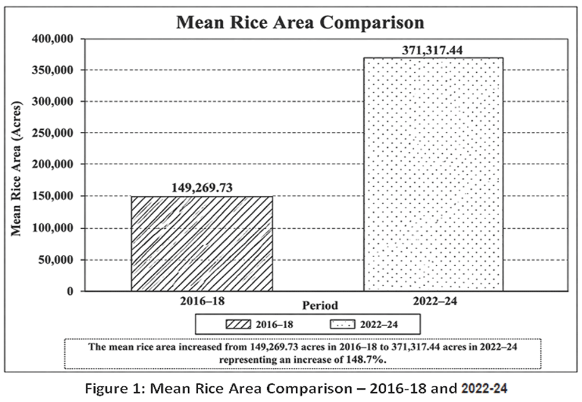 |
Figure 1: Mean Rice Area Comparison – 2016-18 and 2022-24 |
The area of rice grown in Telangana has grown considerably in the past three years. 2. The expansion is strongly associated with increased irrigation availability and infrastructure development. 3. The southern Agro-Ecological Zone (AEZ) has experienced the highest relative growth. 4. In some areas, crop diversification has gone down because of rice monocropping. 5. Relative inter-district variation in rice area declined as rice cultivation intensified across a larger number of districts.” This is scientifically supported by the CV decline from 72.08% to 67.85%.
Table 1: Shows the average rice area for each district from 2016 to 2018 and from 2022 to 2024, broken down by season and irrigation status: It Shows the exact distribution of irrigated and unirrigated rice areas in each district from 2022 to 2024, broken down by Kharif and Rabi seasons. It shows how irrigated rice is the most common type and how it grows in different seasons.
Temporal Dynamics of Rice Area in Telangana (2016–18 versus 2022–24)
Analysis of Descriptive Statistics: The three-year average analysis shows that the rice area in Telangana grew a lot between 2016 and 2018 and again between 2022 and 2024.
Table 2: Descriptive Statistics of District-wise Rice Area in Telangana, 2016–18 and 2022–24
|
Statistic |
2016–18 |
2022–24 |
|
Mean Area (acres) |
149,269.73 |
371,317.44 |
|
Standard Deviation |
107,594.60 |
251,945.37 |
|
Coefficient of Variation (%) |
72.08 |
67.85 |
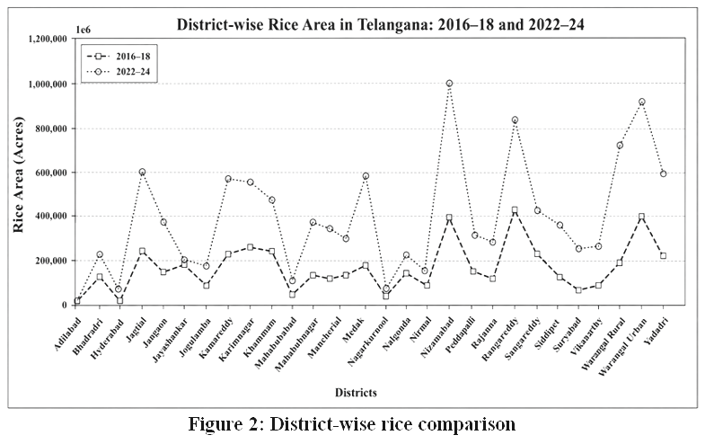 |
Figure 2: District-wise rice comparison |
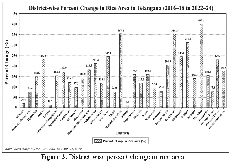 |
Figure 3: District-wise percent change in rice area |
Explanation
The average district rice area grew by 148.7%, which shows that the state as a whole is growing quickly. Table 2 shows that the standard deviation went up, which means that the absolute dispersion got bigger. But CV dropped from 72.08% to 67.85%, which suggests that the relative spatial stability has increased. Growth happened in most districts, not just in the areas where rice is grown.
Growth Rate and Change Analysis: Percent Change
The largest percentage increases were in Vikarabad (404.18%), Rangareddy (355.79%), Nagarkurnool (355.15%), Siddipet (311.29%), and Medak (246.27%). This shows that rice is spreading into districts that were less densely populated before.
Compound Annual Growth Rate (CAGR): If you look at a 6-year period, several districts had CAGR above 25%, which means that the structure was changing quickly. Vikarabad had a CAGR of 30.95%, while Siddipet had a CAGR of 26.58%. These growth rates are very high for an area that grows staple crops, which shows that policies are changing things.
Paired t-Test Analysis: The results of the paired t-test indicate a statistically significant increase in district-wise rice area between the two triennium periods (t = 7.93, df = 32, p = 4.72 × 10-⁹). Because p < 0.01, the rise in rice area between the two trienniums is statistically significant at the 1% level. This indicates that the observed increase represents a statistically significant expansion in the scale of rice cultivation.
District-wise Structural Transformation
Major rice belts in 2022–24: Nalgonda (more than 10 lakh acres), Suryapet (9.2 lakh acres), Nizamabad (8.4 lakh acres), Siddipet (7.3 lakh acres), and Jagtial (6.0 lakh acres). Southern Telangana districts are growing the fastest compared to other areas, while Northern Godavari basin districts are growing the most in terms of size.
Structural Effects: 1. Rice farming now relies heavily on irrigation. 2. Rabi rice grew more because it had enough water. 3. In some districts, crop diversification went down. 4. The difference in space was lessened somewhat. 5. These changes raise sustainability concerns, particularly regarding groundwater stress and soil degradation.
Results
Spatio-Temporal Changes in Rice Cultivation
The analysis reveals a substantial increase in rice cultivation across Telangana between the triennium periods 2016–18 and 2022–24. The average district rice area increased significantly, indicating a marked expansion of rice cultivation throughout the state. The paired t-test confirmed that this increase was statistically significant (p < 0.01), demonstrating that the observed change reflects a systematic agricultural transformation rather than normal annual variation.
Spatial Distribution of Rice Area
Rice cultivation remained concentrated in major agricultural districts such as Nalgonda, Suryapet, Nizamabad, Siddipet, and Jagtial. However, several districts, including Vikarabad, Rangareddy, Nagarkurnool, and Medak, recorded the highest percentage increases in rice area, indicating the emergence of new rice-growing regions. These findings suggest that rice cultivation has expanded beyond its traditional production belts and is becoming more geographically widespread.
Irrigation and Seasonal Intensification
The results indicate that most of the expansion occurred under irrigated conditions, with irrigated rice accounting for the majority of the cultivated area in leading districts. A notable increase in Rabi rice cultivation was also observed, indicating that improved water availability has enabled year-round rice production in many parts of Telangana. While irrigation expansion appears closely associated with these changes, the present analysis identifies this as a statistical association rather than direct evidence of causation.
Spatial Autocorrelation
Spatialstatistical analysis indicates that rice cultivation exhibits positive spatial autocorrelation, particularly during 2022–24 and in the percentage change between the two periods. The presence of significant High–High (HH) clusters suggests that neighbouring districts experienced similar patterns of rice expansion, confirming that the transformation of rice cultivation is spatially structured rather than randomly distributed. This strengthens the evidence for regional agricultural restructuring across Telangana.
Sustainability Implications
The observed expansion of irrigated and Rabi rice highlights the increasing dependence of Telangana’s agricultural system on assured irrigation. Although the present study does not directly measure groundwater depletion, soil degradation, or crop diversification, the results indicate potential sustainability challenges associated with continued rice intensification. These findings underscore the need for region-specific planning that balances agricultural productivity with efficient water management and sustainable cropping systems.
Discussion
Overall, the study demonstrates that Telangana has experienced a significant spatio-temporal transformation in rice cultivation during the study period. The expansion is characterised by a wider geographical distribution, increasing irrigation dependence, and greater Rabi cultivation. These findings provide valuable evidence for agricultural planning and support the development of agro-ecological strategies that promote both food security and long-term sustainability.
Conclusion
This study demonstrates that Telangana has undergone a significant spatio-temporal transformation in rice cultivation between the triennium periods 2016–18 and 2022–24. The transformation is characterised not only by a substantial increase in rice area but also by a clear spatial redistribution of cultivation, increased irrigation dependence, and marked Rabi intensification across contrasting Agro-Ecological Zones (AEZs). The findings indicate that rice cultivation has expanded beyond its traditional production belts into several previously less-intensive and semi-arid districts, reflecting a broader restructuring of the state’s agricultural landscape. The spatial clustering observed in the analysis further suggests that this transformation is geographically organised rather than randomly distributed. Collectively, these patterns indicate a transition towards a more irrigation dependent rice production system with important implications for regional agricultural planning and resource manage–ment. Despite these contributions, the study has several limitations. The analysis is based on district-level secondary data, which may conceal substantial intra-district variation in irrigation access, groundwater conditions, and Crop choices. Further more the study establishes spatial and temporal associations but does not estimate the causal impact of individual irrigation projects, procurement policies, or environ mental factors on rice expansion. Direct measurements of groundwater depletion, soil degradation, and crop diversification were beyond the scope of the available dataset. Future research should therefore focus on quantifying the causal relationships between irrigation expansion, policy interventions, and changes in rice cultivation.
Acknowledgement
I would like to thank the Director of the Centre for Economic and Social Studies (CESS) for allowing me to do the Ph.D. research work. I would like to thank my research guide, Dr Padmanabha Rao, an academic consultant at Ambedkar University, Hyderabad; Dr P. Parthsarathy Rao, a retired scientist from ICRISAT; and Mr Eswara Jagdeesh, a retired statistician from ICRISAT, for their assistance with data analysis Last but not least, I thank Dr Murali Krishna Gumma, Principal Scientist, and Mr Ismail from GIS-IHUB, ICRISAT, for generating the GIS maps. principal scientist and Mr Ismail from GIS-IHUB-ICRISAT for generating the GIS maps.
Funding Sources
The author(s) received no financial support for the research, authorship, and/or publication of this article.
Conflict of interest
The authors do not have any conflict of interest.
Data Availability Statement
This statement does not apply to this article.
Ethical Statement
This research did not involve human participants, animal subjects, or any material that requires ethical approval.
Informed Consent Statement
This study did not involve human participants, and therefore, informed consent was not required.
Clinical Trial Registration
This research does not involve any clinical trials.
Permission to reproduce material from other sources
Not Applicable.
Author Contributions
The sole author was responsible for the conceptualisation, methodology, data collection, analysis, writing, and final approval of the manuscript.
References
- Panjala, P.P., Gumma, M.K. and Mesapam, S. (2024). Geospatial assessment of cropping pattern shifts and their impact on water demand in the Kaleshwaram Lift Irrigation Project command area, Telangana. Frontiers in Remote Sensing, 5, 1451594. https://doi.org/10.3389/frsen.2024.1451594.
CrossRef - Saha, P., Bohra, J.S. and Banjara, T. (2023). Diversification of the rice-based cropping system with high-value crops for increased productivity and profitability. Indian Farming, 73(11), 13–16.
- Rautaray, S.K. and Sucharita, S. (2024). Crop diversification for sustainable agriculture. Indian Farming, 74(2), 19–22.
- Mal, T. and Chaudhary, A. (2024). Maize-based diversification options for rice-wheat cropping systems. Indian Farming, 73(12), 23–26.
- Government of Telangana. Statistical Abstract of Telangana. Directorate of Economics and Statistics, Planning Department, Government of Telangana, Hyderabad.
- Government of Telangana. Season and Crop Report, Telangana. Directorate of Economics and Statistics, Government of Telangana, Hyderabad.
Abbreviations
AEZ – Agro-Ecological Zone;
CAGR – Compound Annual Growth Rate;
CV – Coefficient of Variation;
DES – Directorate of Economics and Statistics;
FAO – Food and Agriculture Organization;
GIS – Geographic Information System;
GPS – Global Positioning System;
ICAR – Indian Council of Agricultural Research;
KLS – Kaleshwaram Lift Irrigation Scheme;
LISS – Linear Imaging Self-Scanning Sensor;
LULC – Land Use and Land Cover;
MIS – Micro-Irrigation System;
MSP – Minimum Support Price;
NDVI – Normalized Difference Vegetation Index;
NRSC – National Remote Sensing Centre;
Rabi – Winter Cropping Season;
RS – Remote Sensing;
SD – Standard Deviation;
SPI – Standardized Precipitation Index;
SWOT – Strengths, Weaknesses,
Opportunities and Threats;
TGA – Telangana Geographical Area;
TS – Telangana State;
UTM – Universal Transverse Mercator.